GeographyMajor geographic areas in Canada

|
The Interior Plains were caused by glaciation from the last Ice Age. There are glacial deposits in the area, like glacial lakes. More land was eroded over time. The land is mostly made up of sedimentary bedrock (shale, sandstone, and silt stone). Oil, natural gas, and fossil fuels deposits were caused by decomposed plants and animals being crushed and compressed. Peace Rivers are evidence of glaciation in the area. |

Interior plains is highlighted beige ( Alberta and Northwest territories)
Climate
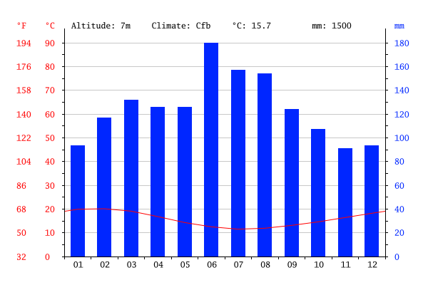
The Interior Plains are a cool region, with average temperatures in the winter between -10 degrees Celsius and -20 degrees Celsius. In the summer, the average temperature is about 20 degrees Celsius. The temperatures can get much higher and lower, up to 40 degrees Ceslius and down to -40 degrees Celsius. The prairies are also quite dry, getting between 300mm to 500mm of rain each year.
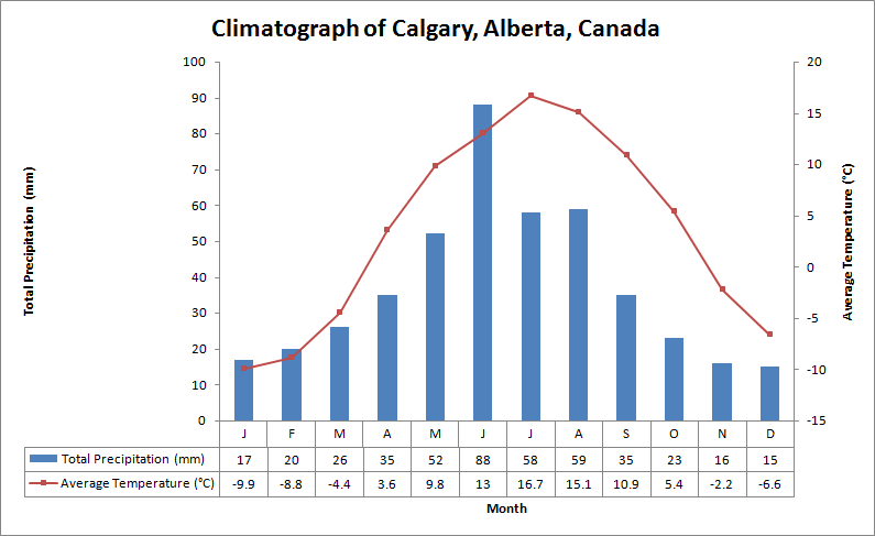
Calgary |
Edmonton |
Fort Vermilion |
Flora
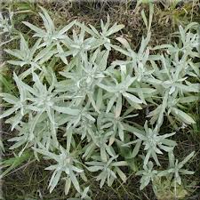
The plants in the Interior Plains are mostly grasses, Other plants in the Plains include pine trees, fur trees, spruce trees, cottonwood trees, moss and shrubs. Since the prairies are dry and open to fires, the plants have adapted to survive (deep roots, narrow leaves, small flowers that are pollinated by wind, and ability to photosynthesize without using up moisture.
Fauna |
|
Hundreds of different species live in this region, and they have adapted to this environment. For example, elk, deer, and bobcats find shelter in river valleys. Other animals borrow holes in the ground to escape the heat/cold. Reptiles, like snake and lizards,hibernate underground during the winter. Bison used to graze on the prairies, and were hunted by people,bears, and wolves.

Grizzly bear
Human Geography |
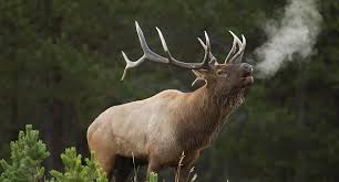
elk
|
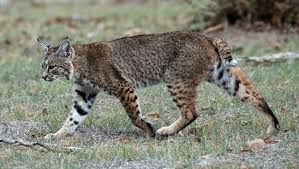
Linx
|
The total population is around 5.3 million people, and most live in the Southern area. The North has a population of around 22 000 people, and the colder temperatures and smaller land area is to blame. The central area of this region has about 812 000 people. This is because of warm weather. However, in the South, there is a spike to around 4.5 million people. There are more people because of farming conditions, oil fields, and how close it is to the United States. Most major cities are in the South, including Winnipeg, Calgary, and Edmonton. Most major industries in the Plains are natural resources found in the area, such as oil, lumber, farming, and ranching.
Economy
In the past, the economy of the Interior Plains was based on the fur trade, as the Europeans bought the fur that the Native Peoples acquired during the bison hunt. Other past industries include forestry, agriculture and farming, especially of wheat, ranching, and the petroleum industry. Today, the biggest industry in the Interior Plains is the petroleum industry. The big break came when the Leduc Oil Field opened Southwest of Edmonton in 1947. It was an extreme success, and helped the petroleum industry take over the economy of Alberta. Although most of the petroleum industry is controlled by other countries, companies like Husky Oil and Petro-Canada are Canadian-owned. Forestry, saw mills, pulp mills, ranching, and agriculture are all still major industries as well. Agriculture, however, has slightly changed. In today's economy, the value of certain crops depends on the market, so farmers today also grow canola, beans, carrots, and potatoes as well as wheat. Calgary has also emerged as a Western center for financial and corporate head offices. The biggest sources of exporting goods in the Interior Plains are crops and oil. The most used natural resource in this region is oil.
Environmental Concerns
Agricultural runoff is a huge problem in the Plains, and it happens when extra water on the surface of the soil runs off into water bodies. Due to chemicals in the soil, the run off is contaminated as it goes. As a result, the water body the runoff drains into is also contaminated with pollutants. Other types of pollution in agricultural runoff include animal waste, herbicides, nitrogen, phosphorous, and irrigation water. Two of the effects are: death of marine life and polluted drinking water. People have caused this problem by using excess fertilizer and pesticides. Some solutions are: nutrients management (applying fertilizers and pesticides when needed) and planting buffers( trees and shrubs to filter out the pollutants)But, some of these solutions cause conflict. Some people say that fertilizers and pesticides are not needed at all, and others say they are needed to keep the produce healthy. Some people have also said that putting limits on farm animal movement is animal abuse. I think the best solutions is nutrient management because it's effective and direct.
Compared location
Whangarei, newzealnd
|
that is similar to the Prairies is new zealand The temperatures in the are close to the temperatures in the Prairies, and the humidity is also close to the same. However, this region gets about 250mm more precipitation than the Interior Plains. Also, Whangarei gets its precipitation at different times of the year. Naturally occurring plants and animals in the region are cabbage trees, rimu, takahe, matai, kiwis and stoats. Ranching sheep is very popular to the area. Kiwis have adapted by losing their ability to fly and increasing their body size because there are no predators to run from.
The main industries in New Zealand are agriculture and ranching.
Sheep ranching is the most common but cattle and chickens are becoming more common and necessary as well. |
